Monday, June 11, 2018

Y16 Steel Pole 3D Mapping

Part of my job is to survey locations for power poles to be inserted. This requires many hours of careful planning to find the straightest and usually the most level areas for pole placement. Y16 is a project that goes from the north side of  Portage to the north side of Pairie du Sac, about 30+ miles of transmission poles will be needed for this project. One of the tools that would be beneficial to this project is a 3D projection of the transmission poles and a elevation profile of the area where they will be located.

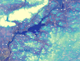
To do this project I used the staking data for the center hubs of the poles in order to locate their location. This data was projected in NAD 83 Wisconsin South so I set the projection to match the hubs and continued on with the project. I then used a DEM that I downloaded from the Wisconsin DNR  to get elevation data for the surrounding area. I used a 10m DEM to get basic elevation data and merged it with Bing Aerial photogrammetry data to create a map that holds true to the surrounding area.

DEM created using Bing and WI DNR data
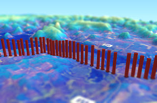
To create the point shape files from the CSV file that I had on the center hub stakes for the power poles I used the feature in QGIS to create a layer from a Delimited Text File. This allows me to use the coordinates that I had stored in the CSV file to be projected in QGIS as a point shape file.
Points created from CSV file


After the points have been successfully created I had to give it elevation data and create a 3D shape file for the power pole. I downloaded the QGIS2threejs app and used the point feature to give a cylinder object to the power poles. Then to give a width of the poles the value was set to 75 and height was set to a value of 100. The z-coordinate was set relative to the DEM so everything would sit flush and I wouldn't have any errors or floating points.

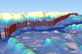
Elevation profile and location of Transmission Towers
The final map was created by adding the data from the created DEM into QGIS2threejs I set the base size to 600 and exaggerated the vertical projection by 6 to show the hills and reliefs of the Prairie Du Sac area. The final result is a aesthetically pleasing 3D map that shows elevation, pole location and direction of where the poles will be going. After using a few tilt shift filters I have a very pleasing 3D representation of  the Y16 project.
Y16 Elevation Profile

Bike Trails of Madison Wisconsin


Living in Madison has opened my door to a wide variety of outdoor activities that I haven't had access to while living in other cities like Eau Claire. I purchased a bicycle recently to travel around the city in a more Eco-friendly way. This is beneficial to me since it seems like every street in Madison is under construction right now and traffic is terrible! The biking culture in Madison is excellent, trails intersect and weave between downtown, west side, east side and even go to the belt line south of the city. Since Madison is such a bike friendly city I thought it would be a fun idea to dive into a different kind of road map. This map shows the diverse and well crafted bike trails throughout Madison Wisconsin.

This map was created using data supplied from Dane County, Open Street Map, and bicycle data from UW-Madison. I used the TIGER files from Dane County to show the belt line and highways. This data was used to gather a sense of scale and show how  you can get pretty much anywhere riding a bike in Madison. The Open Street Map data was used as a base layer but made transparent so you can see the bike trails and intersecting roads.


Most of the road data was omitted to focus more on the bike paths themselves. I also included the B-Cycle rental bike stations that are scattered throughout the city. These B-Cycle stations are cheap and easy to use for just a couple dollars a day and you can rent a bike cheaply and reliably in Madison. Bike Facilities are also found along major bike trails in case of accidents such as flat tires or a broken chain. This is one of the many reasons why Madison is such a bike friendly city.

This Bike map of Madison gives a large scale presentation of the bike trails in the city. The  city has quite a few trails that go from east side to the west side all the way to the belt line. Many people in Madison use these bike trails everyday to commute to work, get groceries or just for fun. The biking community in Wisconsin is on par with some European cities such as Amsterdam and Copenhagen. I for one, am very excited to start biking along this beautiful city to take in as much of the trails as I can and to skip traffic on my way to work.