Part of my job is to survey locations for power poles to be inserted. This requires many hours of careful planning to find the straightest and usually the most level areas for pole placement. Y16 is a project that goes from the north side of Portage to the north side of Pairie du Sac, about 30+ miles of transmission poles will be needed for this project. One of the tools that would be beneficial to this project is a 3D projection of the transmission poles and a elevation profile of the area where they will be located.
To do this project I used the staking data for the center hubs of the poles in order to locate their location. This data was projected in NAD 83 Wisconsin South so I set the projection to match the hubs and continued on with the project. I then used a DEM that I downloaded from the Wisconsin DNR to get elevation data for the surrounding area. I used a 10m DEM to get basic elevation data and merged it with Bing Aerial photogrammetry data to create a map that holds true to the surrounding area.
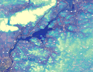 |
| DEM created using Bing and WI DNR data |
To create the point shape files from the CSV file that I had on the center hub stakes for the power poles I used the feature in QGIS to create a layer from a Delimited Text File. This allows me to use the coordinates that I had stored in the CSV file to be projected in QGIS as a point shape file.
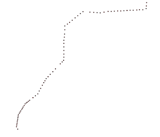 |
| Points created from CSV file |
After the points have been successfully created I had to give it elevation data and create a 3D shape file for the power pole. I downloaded the QGIS2threejs app and used the point feature to give a cylinder object to the power poles. Then to give a width of the poles the value was set to 75 and height was set to a value of 100. The z-coordinate was set relative to the DEM so everything would sit flush and I wouldn't have any errors or floating points.
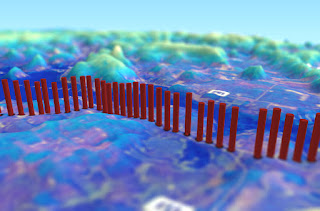 |
| Elevation profile and location of Transmission Towers |
The final map was created by adding the data from the created DEM into QGIS2threejs I set the base size to 600 and exaggerated the vertical projection by 6 to show the hills and reliefs of the Prairie Du Sac area. The final result is a aesthetically pleasing 3D map that shows elevation, pole location and direction of where the poles will be going. After using a few tilt shift filters I have a very pleasing 3D representation of the Y16 project.
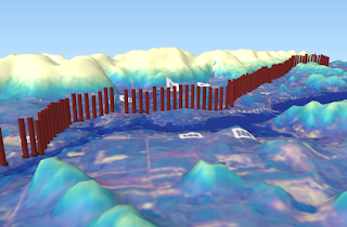 |
| Y16 Elevation Profile |


No comments:
Post a Comment